From Barberey-Saint-Sulpice to Troyes via the greenways

Exploring the greenways around Troyes. This route follows a cycle path for the most part. Starting from the car park at the start of the Haute-Seine Canal Greenway in Barberey, it takes you to the start of the Viennes Greenway.

Details

1136456
Creation:
Last update:
Last review:
  • Touring/Gravel
    Activity: Touring/Gravel
  • ↔
    Distance: 11.23 mi
  • ◔
    Duration according to the author: 2.5 hrs 
  • ▲
    Difficulty: Easy

  • ⚐
    Back to start: Yes
  • ↗
    Ascent: + 62 ft
  • ↘
    Descent: - 62 ft

  • ▲
    Highest point: 387 ft
  • ▼
    Lowest point: 322 ft
  • ⚐ Country: France
  • ⚐ City: Barberey-Saint-Sulpice (10600)
  • ⚑
    Start/End: N 48.342547° / E 4.038928°
  • Accessible from the train station Gare de Troyes.
  • ❏
    IGN map(s): Ref. 2817SB

  • ◶
    Type of surface:
  •  
     
     
     33% Road  34% Byway  33% Path
  • Hour-by-hour weather

Photos

Description of the route

From Barberey-Saint-Sulpice to Troyes

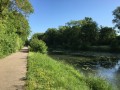
(S/E) Car park at the start of the Haute-Seine Canal Greenway in Barberey. Head down the path alongside the canal, turn right to cross the departmental road and follow the Haute-Seine Canal Greenway towards Troyes.

(1) Cross the canal bridge over the Seine and continue along the Greenway; go through a tunnel under the Rocade ring road, then follow the Canal de Saint-Étienne.

(2) Turn right when you reach Avenue Aristide Briand (the entrance to Fouchy Municipal Park is fifty metres further on).

Turn left immediately onto Rue Georges Merle, which runs alongside Fouchy Park, then continue along Rue Jacques Bachot.

At the junction with Chemin des Hauts Cortins, turn right for fifty metres, cross the road and go through the tunnel that runs under the railway line. Turn left onto Chemin des Champs de la Loge.

(3) Leave the road on your right – this will be the route back – and continue for 150 metres.

(4) Turn right into Parc de la Cité Administrative des Vassaules. The cycle path forms a circular route here. It goes round the top of the pond before descending to the car park, which you cross to the right until you reach the entrance gate.

(5) Turn left onto the left-hand pavement of Rue du Commandant Pierre Mulsan.

(6) When you reach the junction with Avenue Chomedey de Maison Neuve, turn left. Follow this avenue along the cycle path on the left-hand pavement.

(7) When you reach the sculpture of a heart, turn right onto Rue Passerat and cycle past Saint-Rémy Church, the market and the rear of the town hall. Continue straight on along Rue Chardonnet and Rue du Palais de Justice.

At the junction with Rue Jaillant Deschainets, turn left and then right onto Rue du Colonel Driant. Cross the Patton roundabout and continue along Rue Voltaire.

(8) As you come off the Pont Voltaire, turn left onto Rue Bégand. At the junction, turn right, go round the roundabout and continue along Rue Jeanne d’Arc. At the Rond-Point Robert Galley, take the path on the right.

(9) This is where the Viennes Greenway begins.

From Troyes to Barberey-Saint-Sulpice

(10) Follow the Vienne Greenway for about a hundred metres, cross the River Vienne, then turn right onto Rue du Paradis.

At the junction with Rue Courtalon, turn right, then go round the roundabout towards Rue Jeanne d’Arc, which passes under the railway line. Cross Boulevard Victor Hugo and then the car park. Opposite the church, turn left onto Rue Raguenau.

(11) Walk round the park and take Rue de la Bonneterie; walk past the former Bourse du Travail and continue straight on down Rue Émile Zola. Cross Place de la Préfecture, then walk up Rue Roger Salengro.

(12) At the Petit Louvre, turn left, then immediately right. Cross the square in front of the cathedral and turn left into Rue de la Cité.

(13) Turn right along the Quais des Comtes de Champagne and head towards the sculpture of a heart.

(7) Continue straight on until you reach the junction with Rue du Commandant Pierre Mulsan.

(6) Turn right and head towards the entrance gate to the Cité des Vassaules.

(5) Turn left into Rue Herluison.

(3) At the end of the street, continue a few metres to the left, then go through the tunnel under the railway line. Turn right onto Chemin des Hauts Cortins, then left onto Rue Bachot.

Continue along Rue Condorcet and Rue Merle. At the T-junction, turn right onto Avenue Aristide Briand and follow it for a good hundred metres.

(2) Carry on to the left and then follow the Canal Saint-Etienne. Go under the ring road through the tunnel.

(1) Cross the Canal Bridge, then Route de Sainte-Maure, and head for the car park (S/E).

Waypoints

  1. S/E : mi 0 - alt. 325 ft - Barberey Cycle Route car park
  2. 1 : mi 0.62 - alt. 325 ft - Canal Bridge - Seine [la]
  3. 2 : mi 2.2 - alt. 331 ft - Hospice/Briand junction
  4. 3 : mi 2.84 - alt. 335 ft - Chemin des Champs de la Loge, junction of the circular route
  5. 4 : mi 2.94 - alt. 335 ft - An entrance to the Parc de la Cité Administrative
  6. 5 : mi 3.47 - alt. 335 ft - Entrance gate to the Cité des Vassaules
  7. 6 : mi 3.59 - alt. 338 ft - Mulsan/Chomedey junction
  8. 7 : mi 4.56 - alt. 351 ft - The Heart of Troyes
  9. 8 : mi 5.31 - alt. 371 ft - Voltaire Bridge
  10. 9 : mi 5.71 - alt. 354 ft - Start of the Voie des Viennes
  11. 10 : mi 5.83 - alt. 354 ft - Junction of the Voie des Viennes and Rue du Paradis
  12. 11 : mi 6.24 - alt. 381 ft - Park
  13. 12 : mi 6.87 - alt. 351 ft - Hôtel du Petit Louvre
  14. 13 : mi 7.13 - alt. 351 ft - Quays of the Counts of Champagne
  15. S/E : mi 11.23 - alt. 325 ft - Barberey car park

Notes

It is easy to park your car at the car park at the start of the Haute-Seine Canal Greenway in Barberey to begin a cycle ride, either towards Saint-Oulph or towards Troyes.
However, parking spaces are scarce in the streets around the start of the Vienne Greenway. The Troyes Champagne Métropole car park is not open to the public.

(9) You can extend this route with a return trip along the Voie des Viennes, which follows the River Vienne through wooded countryside.

Four Greenways:

  • The 27km Haute Seine Canal Greenway links Barberey to Saint-Oulph.
  • The 13 km Seine Greenway, from Barberey to Saint-Julien, passes through La Chapelle-Saint-Luc and Troyes.
  • The 42km Lakes Cycle Route, from Saint-Julien to Dienville, connects Troyes to the lakes of the Forêt d’Orient.
  • The 8km ‘Voie des Viennes’ passes through the towns of Troyes, Sainte-Savine and Saint-André-les-Vergers.

Four links for more detailed information:
Voie Verte des Viennes – Sainte-Savine
Haute-Seine Canal Greenway
Greenways of Aube in Champagne
Cycling in Aube

Worth a visit

Discover the Barberey Canal Bridge, which has been restored and adapted to allow pedestrians and cyclists to cross. Information boards explain its history and how it is used.

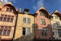
A tour of the neighbourhoods of La Chapelle-Saint-Luc, Saint-Julien and Troyes town centre, including the cathedral, parks and half-timbered houses.

Fouchy Park in La Chapelle-Saint-Luc is well worth a visit.

Reviews and comments

gazok54
gazok54 ★

Good evening, Citron10
It’s your walk, Citron10, so you can edit it as you like. Please do, however, follow Visorando’s posting rules

Machine-translated

Citron10
Citron10
• Edited:

Thank you for the corrections.

The title (in bold):
From Barberey-Saint-Sulpice to Troyes
was deleted by mistake, I think. We could even put it in bold and underline it. That’s the outward leg of the walk.

At (3), delete ‘opposite’, which is no longer relevant.

At (9), add a full stop after ‘Viennes’ and then leave at least one blank line.
‘From Troyes to Barberey-Saint-Sulpice’ is a heading. This is the return leg of the walk.

Citron10

Machine-translated

For more walks, use our search engine .

The GPS track and description are the property of this route's author. Please do not copy them without permission.