


Comox - Nymph Falls And Barber's Hole
Details
Creation:
Last update:
–
–
-
 Activity: Walking
 -
 Distance: 2.03 mi
 -
 Average duration: 1h 05
 -
 Difficulty: Not specified
 -
-
 Back to start: Yes
 -
 Ascent: + 144 ft
 -
 Descent: - 144 ft
 -
-
 Highest point: 456 ft
 -
 Lowest point: 331 ft
-
 Start/End: N 49.671718° / W 125.082521°
 -


 Hour-by-hour weather


Waypoints
- S/E : mi 0 - alt. 407 ft
- S/E : mi 2.03 - alt. 407 ft
Other walks in the area
Nymph Falls Nature Park
 Visorando Member
 2.15 mi
+144 ft
-131 ft
1h 05
2.15 mi
+144 ft
-131 ft
1h 05
 Easy
Easy
 Departure from Canada
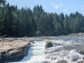
Short walk in Nymph Falls featuring a well-marked trail through a dense Pacific Northwest forest of firs, cedars, and mossy trees. The path leads directly to the Puntledge River, opening onto smooth bedrock shelves where glacial waters cascade over stepped rock ledges.
For more walks, use our search engine .
The GPS track and description are the property of this route's author. Please do not copy them without permission.

