
Nymph Falls Nature Park

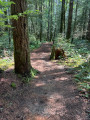
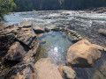
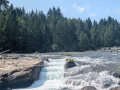
Short walk in Nymph Falls featuring a well-marked trail through a dense Pacific Northwest forest of firs, cedars, and mossy trees. The path leads directly to the Puntledge River, opening onto smooth bedrock shelves where glacial waters cascade over stepped rock ledges.

Details

102384281
Creation:
Last update:
Last review:
  • Walking
    Activity: Walking
  • ↔
    Distance: 2.15 mi
  • ◔
    Average duration: 1h 05 
  • ▲
    Difficulty: Easy

  • ⚐
    Back to start: Yes
  • ↗
    Ascent: + 144 ft
  • ↘
    Descent: - 131 ft

  • ▲
    Highest point: 538 ft
  • ▼
    Lowest point: 348 ft

Photos

Description of the walk

Start: NYMPH Falls Parking (N 49.67181 W 125.08248)

Nestled just ten minutes west of Courtenay (by car), the walk in Nymph Falls is a quintessential Pacific Northwest stroll. The well-marked path winds beneath a dense canopy of towering Douglas firs, Western red cedars, and moss-draped branches.

The trail soon opens onto sprawling, smooth bedrock shelves that flank the Puntledge River. Here, glacial-fed waters churn into foaming whitewater, cascading down a series of stepped, natural rock ledges.


Waypoints

  1. S/E : mi 0 - alt. 469 ft - NYMPH Falls Parking
  2. S/E : mi 2.15 - alt. 469 ft - NYMPH Falls Parking

Notes

Dogs are allowed (and often off-leash under control), parking is free at the trailhead off Forbidden Plateau Road, and outhouses are available near the entrance.

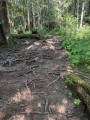
Although the route is very easy, the path can be very rooty and a tripping hazard.

For more walks, use our search engine .

The GPS track and description are the property of this route's author. Please do not copy them without permission.