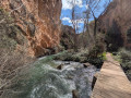
Red Canyon of Teruel

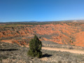
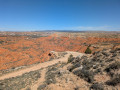
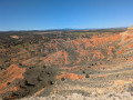
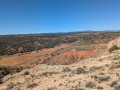
A leisurely walk right on Teruel’s doorstep, with spectacular scenery all along the way. The first half is straightforward, with the Red Canyon on your right as you head up the forest track: magical, like a scene from a Western. After the gentle path, you’ll find yourself on a plateau offering a sublime panorama. The return journey takes you along a dry stream bed, riding over silt and gravel, but with beautiful views throughout: hills, ravines, cliffs, and that ever-present red earth, creating a unique atmosphere. It is said that the Battle of Teruel took place here.

Details

75584735
Creation:
Last update:
Last review:
  • Walking
    Activity: Walking
  • ↔
    Distance: 5.04 mi
  • ◔
    Average duration: 2h 50 
  • ▲
    Difficulty: Easy

  • ⚐
    Back to start: Yes
  • ↗
    Ascent: + 551 ft
  • ↘
    Descent: - 561 ft

  • ▲
    Highest point: 3,428 ft
  • ▼
    Lowest point: 2,884 ft

Photos

Description of the walk

After leaving the road from Teruel, a track leads you to a dry riverbed. You can park there. Personally, I parked just beyond that, under a solitary tree, before the track climbs up to the right. It’s also possible to park 100 to 200 metres further on. 

(S/E) Follow the track in the direction of arrival and cross a rugged, ravined landscape, where a perfume advert featuring Johnny Depp was filmed in early April 2025. You’ll reach a junction marked by signs that a private individual has put up to block the way: this is to mark the boundary of a property on the right.

(1) Take the forest track opposite, slightly to the left, and head towards the plateau. Don’t miss the famous Canyon Rojo on your right – it’s stunning and colossal! You’ll reach a junction. 

(2) Carry on to the left to reach the edge of the plateau. 

(3) Stunning views, but be careful at the edge – you reach it very quickly and it drops away steeply: watch out for dogs and children. Once you’ve spotted it, a path runs along the plateau for a leisurely walk and reaches the highest point in the area: a commanding view over much of Teruel and the plateau. There you’ll find a remnant from the Battle of Teruel.

(4) Carry on to begin the most technical part of the hike: a short, interesting descent leading onto a track suitable for vehicles. 

(5) You’ll find yourself right in the middle of a rugged, red-earth landscape, somewhere between science fiction and a Western: both in atmosphere and scenery. It’s less spectacular than the canyon at the start, but it’s superb and well worth the effort to push on this far. It’s possible to climb down to the bottom of the various ravines, but do so at your own risk, and bear in mind that you’ll need to find a way out. Climbing back up this crumbly terrain seems rather risky. Continue the route to the left until you reach a junction marking the end of the scenery 

(6) Turn left. The rest of the walk follows a dry riverbed, from where you have a lovely view down onto the plateau where the first part of the walk takes place. The ground consists of gravel and sand, and paths allow you to get closer to the foot of the cliffs. Carry on straight ahead to the car park (S/E). 

Waypoints

  1. S/E : mi 0 - alt. 2,910 ft - Parking at the side of the path
  2. 1 : mi 0.57 - alt. 3,061 ft - Private property boundary, on the left
  3. 2 : mi 0.92 - alt. 3,327 ft - Junction
  4. 3 : mi 1.33 - alt. 3,392 ft - Summit of the plateau
  5. 4 : mi 2.09 - alt. 3,383 ft - Highest point: remains of the Battle of Teruel
  6. 5 : mi 2.33 - alt. 3,297 ft - Vehicle-accessible track
  7. 6 : mi 2.64 - alt. 3,241 ft - Junction, turn left
  8. S/E : mi 5.04 - alt. 2,900 ft - Parking at the side of the path

Notes

(3) Please note: on the western side there are cliffs, which you approach without realising it. There is a risk of falling without warning. 

There are few difficult sections, but the terrain is very stony – watch your ankles.

There is no shade. The walk is short, but depending on the weather, make sure you bring adequate protection. In late March, there’s a cool breeze and the sun is scorching – a bit treacherous. In the full July sun, the temperature soars rapidly. 

Reviews and comments

4.8 / 5
Based on 3 reviews

Reliability of the description
4.3 / 5
Ease of following the route
5 / 5
Route interest
5 / 5
User 29912396
• Edited:

Overall rating : 4 / 5

Date of your route : Jul 16, 2026
Reliability of the description : ★★★☆☆ Average
Ease of following the route : Not used / Not applicable
Route interest : ★★★★★ Very good
Very busy route : No

We couldn’t easily work out which paths to take, so we decided not to do the circular route but just a short walk instead.

Machine-translated

Pep 64
Pep 64

Overall rating : 5 / 5

Date of your route : May 11, 2026
Reliability of the description : ★★★★★ Very good
Ease of following the route : ★★★★★ Very good
Route interest : ★★★★★ Very good
Very busy route : Yes

The guide on your website is extremely accurate.
Thanks to visorando

Machine-translated

User 15818064

Overall rating : 5 / 5

Date of your route : Sep 03, 2025
Reliability of the description : ★★★★★ Very good
Ease of following the route : ★★★★★ Very good
Route interest : ★★★★★ Very good
Very busy route : No

A very pleasant, easy, peaceful and exotic route. The first part is the most interesting.
Be careful of the heat, however, as there is no shade on the entire route.
The return trip through the canyon is a bit long, but the scenery is beautiful.

Machine-translated

For more walks, use our search engine .

The GPS track and description are the property of this route's author. Please do not copy them without permission.