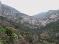
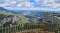
The Estagnol circular route and the two caves: Olivier and Cellier

A wooded climb along a path, which gets a bit steep towards the end, through a thicket of oaks and arbutus trees, towards the Mas de l’Estagnol. Cross the Combe Malafosse then climb towards the Mas de l’Arboussier.
A short detour along the slope of the Combe de la Blande to visit the Baume Cellier, then back towards the Mas de l’Arboussier to reach the Baume de l’Olivier and its neighbour, the Baume Charlotte, with a brief detour to the Aven des Trois Trous. The return journey is via the Combe Malafosse.

Details

67330085
Creation:
Last update:
Last review:
  • Walking
    Activity: Walking
  • ↔
    Distance: 7.04 mi
  • ◔
    Average duration: 4h 40 
  • ▲
    Difficulty: Moderate

  • ⚐
    Back to start: Yes
  • ↗
    Ascent: + 1,677 ft
  • ↘
    Descent: - 1,654 ft

  • ▲
    Highest point: 1,240 ft
  • ▼
    Lowest point: 236 ft

Description of the walk

Park in the car park near the Belbezet dam.

(S/E) Follow the D4 towards Saint-Guilhem for a few metres, taking great care (bend). Then take the track on the right for about a hundred metres.

(1) Leave the track and follow a path on the left which climbs steadily, becoming a little steeper in the final few metres, to reach the ruined farmhouse of L’Estagnol.

(2) Take the path on the left in front of the farmhouse, leaving the one leading to Roc Trinquat on your right. The path descends rapidly into the Combe Malafosse, crosses it and climbs gently up the right bank to reach a junction.

(3) Continue climbing to the right towards the ruins of the Mas de l’Arboussier. Walk past the farmhouse and continue the climb.

(4) At the next crossroads, keep to the right to continue climbing northwards, along the slope of the Combe de la Blande, following the first ‘ear’ of the valley to the Baume Cellier.

(5) When you reach the Baume Cellier, situated below and to the right of the path, turn back towards the previous junction.

(4) Then take the path that runs flat out to the right, towards the Baume de l’Olivier. On this second “ear”, the path passes through several valleys, including the Combe du Sergent, in a damp forest.

(6) At the Baume de l’Olivier, a south-facing clearing offers a pleasant spot for lunch. You can then turn back or carry on a little further to the Aven des Trois Trous, another possible spot for lunch. The karstic cave of the Three Trous opens out onto a small hillock to the left of the path. Don’t miss it, or you risk going too far towards Saint-Guilhem-le-Désert. This is the tip of the ‘ear’ and the point at which you turn back along the same path.

(7) Return to the junction with the Combe de la Blande at the crossroads you passed on the way out.

(4) Continue to the right, in the opposite direction to the outward journey, passing the ruins of the Mas de l’Arboussier and returning to a junction you passed on the way out.

(3) Take the path on the right, which winds steeply down to the bottom of the Combe Malafosse, then follows the valley downstream towards the south-west. Pass the Combe de Légeaux and join a track.

(8) Follow this track, which continues to run alongside the Combe Malafosse as far as the D4.

(9) Turn left and walk carefully alongside the departmental road to return to the starting car park (S/E).


Waypoints

  1. S/E : mi 0 - alt. 236 ft - Belbezet Dam car park - Hérault (fleuve)
  2. 1 : mi 0.1 - alt. 282 ft - Path to l’Estagnol
  3. 2 : mi 1.3 - alt. 1,004 ft - Mas de l’Estagnol
  4. 3 : mi 1.91 - alt. 958 ft - Lower circular junction
  5. 4 : mi 2.13 - alt. 1,079 ft - Junction. Round trip to both caves
  6. 5 : mi 2.38 - alt. 1,240 ft - Baume Cellier
  7. 6 : mi 3.62 - alt. 958 ft - Baume de l’Olivier
  8. 7 : mi 3.97 - alt. 1,020 ft - Karstic cave of the Three Trouses
  9. 8 : mi 6.53 - alt. 289 ft - Combe Malafosse track
  10. 9 : mi 6.87 - alt. 246 ft - RD4
  11. S/E : mi 7.04 - alt. 236 ft - Belbezet Dam car park - Hérault (fleuve)

Notes

There are a few sections with a slight drop-off on the way to the Baume de l’Olivier.
Do not get too close to the karstic caves to avoid accidents.
Bring a head torch to visit the Baume Cellier.
Take care when walking alongside the RD4.

Reviews and comments

4.4 / 5
Based on 3 reviews

Reliability of the description
4.3 / 5
Ease of following the route
4.7 / 5
Route interest
4.3 / 5
Jean-Bernard
Jean-Bernard

Overall rating : 3.7 / 5

Date of your route : Feb 26, 2025
Reliability of the description : ★★★★☆ Good
Ease of following the route : ★★★★☆ Good
Route interest : ★★★☆☆ Average
Very busy route : No

The AR up to point 5 isn’t worth the effort; there’s nothing to see as the trees block any view of the Beaume. There’s a better view 200 metres further on. The path from point 4 towards point 6 tends to become overgrown, with vegetation taking over. At point 7, the view is spectacular and it’s a great spot for a picnic – unless it’s windy, as it was for us!! Be careful: some sections are a bit tricky as we’re on a very steep ledge. Thanks anyway to the author.

Machine-translated

Patrick_Lodeve
Patrick_Lodeve

Overall rating : 5 / 5

Date of your route : Feb 10, 2025
Reliability of the description : ★★★★★ Very good
Ease of following the route : ★★★★★ Very good
Route interest : ★★★★★ Very good
Very busy route : No

After the Estagnol and the stunning Cellier Cave, this route allowed us – despite the bad weather – to explore the highly unusual Baume de l’Olivier and its neighbour, Charlotte, offering, above all, magnificent views over the Combe du Sergent and Balaïssade.

Machine-translated

athmos.oner
athmos.oner

Overall rating : 4.7 / 5

Date of your route : Jan 18, 2025
Reliability of the description : ★★★★☆ Good
Ease of following the route : ★★★★★ Very good
Route interest : ★★★★★ Very good
Very busy route : No

Now that’s a lovely walk, taking you along some much lesser-known paths in this area, even though it’s one we’ve seen time and time again.
I couldn’t find the Baume Cellier at point 4 (didn’t see any signposts). But that doesn’t matter; the view was lovely, just as it was all along the walk.
The other caves require special equipment to visit, and as they’re home to bats, it’s best to leave them in peace.
I didn’t come across many people, and it was in complete tranquillity that I was able to enjoy this relatively easy walk, which does, however, require walking boots and a GPS.

Machine-translated

Other walks in the area

For more walks, use our search engine .

The GPS track and description are the property of this route's author. Please do not copy them without permission.