Circular route around Soulme via Vodelée-Gochenée

A lovely walk, following theGRP®® “Sentier des Abbayes Trappiste” (SAT), also known asGRP®®125or the “Grande Traversée du Pays de la Forêt de Chimay”.
The idea behind this walk is to cover a section of approximately 6 km along this trail by walking a circular route.
The vast majority of the paths are unpaved, apart from the sections passing through villages and the final climb up to Soulme. The Hermeton, a tributary of the Meuse, is followed for much of the walk.

Details

44062368
Creation:
Last update:
Last review:
  • Walking
    Activity: Walking
  • ↔
    Distance: 8.50 mi
  • ◔
    Average duration: 4h 30 
  • ▲
    Difficulty: Moderate

  • ⚐
    Back to start: Yes
  • ↗
    Ascent: + 725 ft
  • ↘
    Descent: - 722 ft

  • ▲
    Highest point: 794 ft
  • ▼
    Lowest point: 449 ft
  • ⚐ Country: Belgium
  • ⚐ City: Doische 
  • ⚑
    Start/End: N 50.187148° / E 4.73643°
  • ❏
    IGN map(s): Ref. 3008SB
  • Hour-by-hour weather

Description of the walk

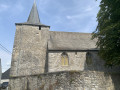
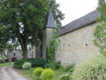
As there is no efficient public transport, park on the right-hand side, on the uphill slope, alongside the wall of the Church of Sainte-Colombe in Soulme, near a lovely picnic table and a few tourist information signs.

(S/E) Walk down the street following theGR®®/GRP®® signposts. At the bottom of the street, turn right.

(1) At the next junction, turn right onto a path that gradually descends towards the Hermeton.

(2) You then walk as close as possible to this river, carefully following theGR®®/GRP®® signposting, until you reach a metal and grating bridge.

(3) Cross the river. The path begins a gentle climb, taking you towards the Chapel of Notre-Dame de Bonne Fontaine. A drinking water point is available just below the chapel.

(4) You cross the chapel grounds, still following theGR®®/GRP®®, and continue along a lovely path that takes you to Vodelée. You enter the village shortly after the path turns into a road.

(5) The first street on the left, called “Voye d’en Haut” (meaning “Upper Street”), takes you off theGR®®/GRP®® route. You then go round a large farm, turning left at the next T-junction. Immediately after this, turn right onto a stony track.

(6) As you approach a building, stay firmly on the stony track, ignoring the grassy path that appears to lead straight ahead. Continue along this track until you reach a field of upright poles. These are used for hop cultivation.

(7) At the corner of this field, turn left, passing the water intake on your left a little further on. Carrying on straight ahead, you’ll pass a partially buried water tower and join a road at a chapel.

(8) Carry on straight ahead along the road (i.e. to the left) until you reach the first junction.

(9) Turn left down Rue Marie-Joséphine Pierre. At the end of this street, turn right and continue towards a junction with a main road.

(10) Cross the road carefully and you’ll be on Rue des Biaux. Stay on this road, heading as straight as possible, until it turns into a stony track. Ignore the private paths on the left and start a slightly steeper climb until you reach a path branching off to the left.

(11) Turn onto this path, which takes you round the edge of a wood. Stay on the main path. You’ll notice that the path you’re following runs parallel to a stony but private path. Carry on along the dirt track and ignore a path on the right, at the entrance to which stands a ‘potale’ stone (a stone with a niche containing a statuette of the Virgin Mary or a patron saint). You’ll begin a gentle descent, followed by a short climb.

(12) At the top of this, keep straight on, following a gentle descent, and avoid the path on the left, which remains level. The descent becomes steeper and steeper, leading you to a bridge over the Hermeton. This is the ‘Pont Christine’.

(13) Once you’ve crossed the bridge, turn left and you’ll be back on theGR®®/GRP®®.
This trail follows the Hermeton upstream and you’ll have to cross a few fords on minor tributaries of this river. In heavy rain, some of these tributaries turn into proper streams!
As with all walks in the woods, you may also come across fallen trees that require you to take a detour of a few dozen metres.

(14) Always ignore any paths on the right and stay as close to the Hermeton as possible. After crossing the courtyard of the Prêle mill, you’ll reach a road (N977).

(15) This road is quite busy. Following theGR®®/GRP®®, turn left and follow it for about 50 metres. Cross it carefully to enter Rue de la Scierie, which lies straight ahead. A building marked ‘Aux Soulmamis’ will serve as your landmark.
Shortly after this, the road gradually steepens, leading you to the entrance to the village of Soulme. At the T-junction, turn right; then, after ignoring a small street on the right, turn immediately left up a steep slope towards the church. Walk round the church to reach your starting point (S/E).

Waypoints

  1. S/E : mi 0 - alt. 669 ft - Car park next to the church - Eglise romane Ste-Colombe
  2. 1 : mi 0.06 - alt. 643 ft - On the gravel track, turn left
  3. 2 : mi 0.63 - alt. 509 ft - L’Hermeton - Hermeton (rivière) - Belgique
  4. 3 : mi 1.17 - alt. 505 ft - Bridge over the Hermeton
  5. 4 : mi 1.38 - alt. 597 ft - Notre-Dame de Bonne Fontaine Chapel
  6. 5 : mi 2.06 - alt. 633 ft - Take the first left in the village
  7. 6 : mi 2.27 - alt. 659 ft - On the gravel track
  8. 7 : mi 3.1 - alt. 758 ft - A corner of a hop field
  9. 8 : mi 3.86 - alt. 781 ft - On the left, on the road
  10. 9 : mi 4.01 - alt. 758 ft - On the left, Rue Marie-Joséphine Pierre
  11. 10 : mi 4.43 - alt. 722 ft - Crossroads
  12. 11 : mi 5.1 - alt. 741 ft - Turn left, along the edge of the woodland
  13. 12 : mi 5.73 - alt. 705 ft - At the top, carry on straight ahead.
  14. 13 : mi 6.19 - alt. 472 ft - Pont Christine,
  15. 14 : mi 6.9 - alt. 469 ft - Turn left onto the GR/GRP
  16. 15 : mi 7.78 - alt. 456 ft - N977
  17. S/E : mi 8.5 - alt. 669 ft - Car park next to the church - Eglise romane Ste-Colombe

Notes

The GPS track was recorded on site. It is fairly reliable and should be consulted in case of doubt.
Hiking poles and good, waterproof footwear are recommended as the route involves crossing several fords.
As there are no refreshment points, please ensure you carry sufficient water and food.
In wet weather, some sections can be quite muddy and are sometimes under water.
Before setting off, don’t forget to check that there are no scheduled hunting activities on your route via the website https://www.chasseonweb.be

All the paths and roads used have been confirmed as accessible via the following pages: https://chemins.be/localite/soulme, https://chemins.be/localite/vodelee and https://chemins.be/localite/gochenee

Worth a visit

The village of Soulme is one of the “Most Beautiful Villages of Wallonia”.
(S/E) Its Sainte-Colombe Church is part of the ‘Églises Ouvertes’ network and is well worth a visit (on your return).
A campsite/accommodation is planned in Soulme as part of the “Grande Traversée de la Forêt du Pays de Chimay”, but its opening is continually being postponed due to regional regulatory requirements.
(4) Notre-Dame de Bonne Fontaine Chapel: a drinking water point below the chapel and a place of worship.
(5) Village of Vodelée. Local produce and lodges available.
(9) Village of Gochenée. Lodges.
(15) Former marble sawmill (not a timber sawmill!).

Always be cautious and plan ahead when you're outdoors. Visorando and the author of this route cannot be held responsible for any accidents occurring on this route.

The GR® and PR® markings are the intellectual property of the Fédération Française de Randonnée Pédestre.

Reviews and comments

5 / 5
Based on 1 review

Reliability of the description
5 / 5
Ease of following the route
5 / 5
Route interest
5 / 5
JFDecoster
JFDecoster

Overall rating : 5 / 5

Date of your route : Jan 29, 2024
Reliability of the description : ★★★★★ Very good
Ease of following the route : ★★★★★ Very good
Route interest : ★★★★★ Very good
Very busy route : No

A superb hike in a magnificent region. Very few tarmac roads and stunning scenery under the late January sun.

Machine-translated

Other walks in the area

For more walks, use our search engine .

The GPS track and description are the property of this route's author. Please do not copy them without permission.