Bois du Breuil and beach at Honfleur

Forest trail, Cote de Grâce and its chapel, Honfleur and its Sainte-Catherine Church, the garden of personalities, walk on the beach and return to the woods with its rhododendrons.

Details

1138453
Creation:
Last update:
Last review:
  • Walking
    Activity: Walking
  • ↔
    Distance: 12.90 km
  • ◔
    Average duration: 4h 00 
  • ▲
    Difficulty: Moderate

  • ⚐
    Back to start: Yes
  • ↗
    Ascent: + 112 m
  • ↘
    Descent: - 116 m

  • ▲
    Highest point: 112 m
  • ▼
    Lowest point: -1 m
  • ⚐ Country: France
  • ⚐ District: Pennedepie (14600)
  • ⚑
    Start/End: N 49.40696° / E 0.193648°
  • ❏
    IGN map(s): Ref. 1711OT
  • Hour-by-hour weather

Photos

Description of the walk

PLEASE NOTE: this walk should be done at low tide

(S/E) From the car park under the trees, head south for 100 metres, then turn left onto Chemin des Riboussailles. After 200 metres, turn right and then 150 metres further on, turn left onto Chemin du Mesnil. At the crossroads with the statue of the Virgin Mary behind you, continue straight ahead.

(1) Turn left onto Chemin des Bruyères, after 1,500 metres, turn left and continue for 700 metres.

(2) Turn left to see the Notre-Dame-de-Grâce Chapel. Outside, a carillon with many bells may startle you when it rings. Continue to the cross, which offers a superb view of Le Havre and the mouth of the Seine. Retrace your steps and turn left onto Chemin de la Côte de Grâce.

(3) Admire the view of Honfleur, then go down the sloping path to join the D279.

(4) Continue straight ahead. Continue along Rue du Puits towards the Church of Sainte-Catherine, which is a marvel of architecture

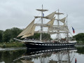
(5) Join the Quai des Passagers.

(6) Continue north along the harbour and the lock.

(7) Turn left into Jardin des Personnalités, crossing it to head towards the Feu de Saint-Siméon at the end of the pier.

(8) Walk down onto the sand at low tide for 4 km to rejoin the Chemin de Bretagne.

(9) Walk up from the beach towards this path, cross the D513 road (take care) by turning left/right for 100m and continue along the Chemin de Bretagne, which climbs for 400m.

(10) Turn left onto this beautiful path lined with rhododendrons (in bloom in May) for 2 km to return to the car park (S/E).

Waypoints

  1. S/E : km 0 - alt. 111 m - Bois du Breuil car park
  2. 1 : km 1.21 - alt. 104 m - On the left, Chemin des Bruyères
  3. 2 : km 3.64 - alt. 95 m - Côte de Grâce
  4. 3 : km 4.36 - alt. 93 m - Mont Joli
  5. 4 : km 4.61 - alt. 34 m - Junction with the D279
  6. 5 : km 5 - alt. 14 m - St. Catherine's Church
  7. 6 : km 5.17 - alt. 2 m - Port of Houfleur - Église Sainte-Catherine de Honfleur
  8. 7 : km 5.75 - alt. 5 m - Entrance to the Garden of Personalities
  9. 8 : km 6.45 - alt. 3 m - Saint-Siméon bonfire
  10. 9 : km 9.64 - alt. 5 m - Entrance to the path leading out of the beach
  11. 10 : km 10.71 - alt. 103 m - Bois du Breuil trail
  12. S/E : km 12.9 - alt. 111 m - Bois du Breuil car park

Worth a visit

Côte de Grâce.
Chapel and its carillons.
St. Catherine's Church.
The Lieutenancy.
Garden of Personalities.
Bois du Breuil.

Reviews and comments

4.7 / 5
Based on 40 reviews

Reliability of the description
4.6 / 5
Ease of following the route
4.6 / 5
Route interest
4.8 / 5
User 20915617

Overall rating : 4.7 / 5

Date of your route : Feb 02, 2026
Reliability of the description : ★★★★★ Very good
Ease of following the route : ★★★★★ Very good
Route interest : ★★★★☆ Good
Very busy route : No

A beautiful route alternating between woods, town, beach and woods.
The beach is rather short and therefore monotonous, but it would be difficult to do otherwise.
Good memories.

Machine-translated

Daniel Gruat
Daniel Gruat

Overall rating : 5 / 5

Date of your route : Jan 03, 2026
Reliability of the description : ★★★★★ Very good
Ease of following the route : ★★★★★ Very good
Route interest : ★★★★★ Very good
Very busy route : No

A very beautiful and varied hike! At point 10, however, in the middle of winter, there is no point in doing two more Kim's. By following the marked path straight ahead, you can reach the car park in less than 10 minutes!

Machine-translated

User 12935391

Overall rating : 5 / 5

Date of your route : Jul 05, 2025
Reliability of the description : ★★★★★ Very good
Ease of following the route : ★★★★★ Very good
Route interest : ★★★★★ Very good
Very busy route : No

A few months ago, we switched from the eTrex 10 to the GPSmap 65. Since we already had the maps, we extended the route through the woods.
The route was pleasant.

Machine-translated

bruanne
bruanne
• Edited:

Overall rating : 5 / 5

Date of your route : Apr 27, 2025
Reliability of the description : ★★★★★ Very good
Ease of following the route : ★★★★★ Very good
Route interest : ★★★★★ Very good
Very busy route : Yes

a superb hike in the hills above Honfleur, starting with a "mandatory" stop at Mont Joli, then a steep descent into the town, a quick detour via the port, followed by a 4 km walk along the beach (best done at low tide) with the wind in your face (due to the Seine estuary) - be careful not to miss point 9 (ideally done with a smartphone and the Viso app) - then it's time to head back up towards the Bois du Breuil
it's a very nice ride, very busy on the first part, then fairly quiet on the way out of Honfleur. If you do it as a race/ride, there's only one downhill and one uphill, but it's "charming". The car park at the Bois de Breuil is shaded and very accessible.

Machine-translated

kar76
kar76

Overall rating : 5 / 5

Date of your route : Mar 31, 2025
Reliability of the description : ★★★★★ Very good
Ease of following the route : ★★★★★ Very good
Route interest : ★★★★★ Very good
Very busy route : No

Beautiful hike. Varied landscapes (countryside, town, sea and woods).
Short lunch break on a terrace in Honfleur.
Beautiful climb up from the Bois du Breuil to finish

Machine-translated

LeMiaou
LeMiaou

Overall rating : 4.3 / 5

Date of your route : Apr 07, 2025
Reliability of the description : ★★★★☆ Good
Ease of following the route : ★★★★☆ Good
Route interest : ★★★★★ Very good
Very busy route : Yes

Good variety of locations, forest, tourist town and sea

Machine-translated

Nicolas LC
Nicolas LC

Overall rating : 5 / 5

Date of your route : Jan 06, 2025
Reliability of the description : ★★★★★ Very good
Ease of following the route : ★★★★★ Very good
Route interest : ★★★★★ Very good
Very busy route : No

A beautiful and varied route that never gets boring: forest, views of the Bay of Seine, crossing Honfleur, walking along the beach and then a lovely climb up to the Bois du Breuil (which is indeed lined with rhododendrons; we were there in December and they weren't in bloom, but it must be magnificent in May: a lovely end to the walk...

Machine-translated

patcross
patcross

Overall rating : 4 / 5

Date of your route : Aug 23, 2024
Reliability of the description : ★★★★☆ Good
Ease of following the route : ★★★★☆ Good
Route interest : ★★★★☆ Good
Very busy route : No

Hampered by incessant rain (20/08), we missed the path to Brittany, which meant we had to retrace our steps, adding to the length of our journey
Given the weather conditions, the beaches were deserted
This hike is well worth doing; in sunny weather, the view must be superb
We couldn't postpone the hike until the next day because we were just passing through Honfleur.

Machine-translated

luodmarcheetreve
luodmarcheetreve

Overall rating : 4.7 / 5

Date of your route : Aug 19, 2024
Reliability of the description : ★★★★★ Very good
Ease of following the route : ★★★★☆ Good
Route interest : ★★★★★ Very good
Very busy route : No

A great way to visit Honfleur on foot, without the hassle of cars.
The route along the beach is on sand. Even when wet, it can be a little difficult for those who are not very fit. You will be pleased to find dirt tracks

Machine-translated

fab_otero
fab_otero

Overall rating : 5 / 5

Date of your route : May 09, 2024
Reliability of the description : ★★★★★ Very good
Ease of following the route : ★★★★★ Very good
Route interest : ★★★★★ Very good
Very busy route : Yes

A beautiful hike that I highly recommend. Several kilometres on very small roads with very little traffic, so it's not too disruptive. The landscapes are varied: countryside, the town of Honfleur, beaches and forests with beautiful rhododendrons in bloom in May. There is a beautiful panoramic view to admire from the heights of Honfleur.

Machine-translated

oce_znn
oce_znn

Overall rating : 4.7 / 5

Date of your route : Aug 26, 2023
Reliability of the description : ★★★★☆ Good
Ease of following the route : ★★★★★ Very good
Route interest : ★★★★★ Very good
Very busy route : No

It was a beautiful hike, despite the heavy rain... We followed the route using the app, which was very helpful! The views are lovely, but be careful at the end of the hike where there is a relatively steep climb and, above all, some foliage blocking the path. It's nothing too serious, but I thought it was worth mentioning. Overall, it's worth doing if you're in the area!

Machine-translated

Chantal L1.
Chantal L1.

Overall rating : 4.7 / 5

Date of your route : Jun 05, 2023
Reliability of the description : ★★★★☆ Good
Ease of following the route : ★★★★★ Very good
Route interest : ★★★★★ Very good
Very busy route : Yes

A very beautiful hike with varied landscapes. I didn't know about the superb view of Mont Joli, Honfleur and the Normandy Bridge. The descent was a little steep afterwards
We set off from the Naturoscope car park and enjoyed one of Honfleur's many terraces on the way back to quench our thirst!

Machine-translated

Louve de NEROBIQUE
Louve de NEROBIQUE

Overall rating : 4.7 / 5

Date of your route : Apr 11, 2023
Reliability of the description : ★★★★★ Very good
Ease of following the route : ★★★★☆ Good
Route interest : ★★★★★ Very good
Very busy route : No

Very beautiful hike. Beautiful views.
Lovely walk through the woods.

Machine-translated

mike78rando
mike78rando

Overall rating : 5 / 5

Date of your route : Aug 26, 2022
Reliability of the description : ★★★★★ Very good
Ease of following the route : ★★★★★ Very good
Route interest : ★★★★★ Very good
Very busy route : No

Very varied route. Small roads, scenic views, passing through the town, a good section along the beach and finally ending in the forest.

Machine-translated

Laurent Daubeuf
Laurent Daubeuf

Overall rating : 5 / 5

Date of your route : Jun 25, 2022
Reliability of the description : ★★★★★ Very good
Ease of following the route : ★★★★★ Very good
Route interest : ★★★★★ Very good
Very busy route : No

A very pleasant and easy hike.
You mingle with tourists on the way to Honfleur, but then it's completely peaceful on the beach, at low tide of course, and in the Breuil woods.
Thanks for sharing.

Machine-translated

Other walks in the area

For more walks, use our search engine .

The GPS track and description are the property of this route's author. Please do not copy them without permission.