
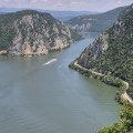
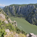
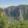
Viewpoint overlooking the Danube in the Iron Gates

A balcony trail 180 metres above the Danube. Almost directly above the river, you’ll see the boats plying its waters and the cliffs on the Serbian bank. After a short climb and a walk across a plateau, several vantage points offer ever-changing views as you continue your hike.

Details

101814038
Creation:
Last update:
Last review:
  • Walking
    Activity: Walking
  • ↔
    Distance: 2.80 mi
  • ◔
    Average duration: 2h 00 
  • ▲
    Difficulty: Easy

  • ⚐
    Back to start: Yes
  • ↗
    Ascent: + 807 ft
  • ↘
    Descent: - 810 ft

  • ▲
    Highest point: 1,024 ft
  • ▼
    Lowest point: 643 ft

Photos

Description of the walk

To reach the starting point of the circular walk, from Orșova take Road 57 and cross the bridge from which you can see the carved face of Decebalus in the cliff face. From this bridge, continue for 6.5 km and park near the start of the walk, which you’ll spot on the left-hand side of the road thanks to the steps leading up to it.

(S/E) Climb the steps and head south-east until you reach a fork in the path.

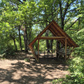
(1) Ignore the tracks on the right which appear to lead back towards the road and which could cause you to take a wrong turn on the way back. Climb up the rather eroded slope. At the top, walk a few metres and look out for a shelter.

(2) Leave the shelter on your left and continue along the roughly level plateau until you reach a fork, which is the junction of the circular route.

(3) Continue south-east, ignoring another path branching off to the left, until you reach the first viewpoint.

(4) Heading north, carefully follow the edge of the cliff whilst enjoying the views over the Danube. Reach the final viewpoint.

(5) The route turns south. Walk through the forest to the junction of the circular route.

(3) Turn right and head towards the junctions (1), then, turning slightly to the right, head for the starting steps (S/E).


Waypoints

  1. S/E : mi 0 - alt. 646 ft - Stairs
  2. 1 : mi 0.05 - alt. 689 ft - Multiple junctions
  3. 2 : mi 0.29 - alt. 1,020 ft - Shelter
  4. 3 : mi 0.38 - alt. 1,007 ft - Junction of the circular loop
  5. 4 : mi 0.73 - alt. 879 ft - First viewpoint
  6. 5 : mi 1.58 - alt. 925 ft - Last viewpoint
  7. S/E : mi 2.8 - alt. 643 ft - Stairs

Notes

The management of the Iron Gates Nature Park (Parcul Natural Porţile de Fier) warns that vipers are present in this area.

There is no water, but there is a shelter (2) along the route.

If Serbia is not included in your mobile plan, it is advisable to switch off your mobile’s internet and phone connections whilst travelling along the Iron Gates to ensure it does not use the Serbian network. Signs reading ‘Roaming involuntar’ provide information about this possibility.

Worth a visit

In Orșova and along the river, boat trips are organised through the gorges. Whether by boat or by car, take in the monumental face of Decebalus carved into a cliff face.

For more walks, use our search engine .

The GPS track and description are the property of this route's author. Please do not copy them without permission.