
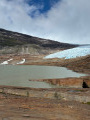
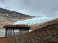
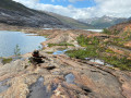
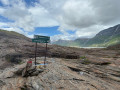
Austerdalsisen in Rana, viewpoint overlooking the Svartisen glacier

Svartisen is Norway’s second-largest glacier by area (370 km²). Situated around thirty kilometres north-west of the town of Mo i Rana and close to the Arctic Circle, it comprises around sixty branches, including Østerdalsisen and Engabreen. One of the easiest access points for viewing the glacier is Østerdalsisen, near Mo i Rana. The name Svartisen derives from the old name ‘Svartis’, which describes the characteristic deep blue colour of the ice, contrasting with the white snow. The ice masses display a spectrum of blue hues, ranging from transparent ice to turquoise and dark blue.

Details

100032686
Creation:
Last update:
Last review:
  • Walking
    Activity: Walking
  • ↔
    Distance: 2.91 mi
  • ◔
    Average duration: 1h 50 
  • ▲
    Difficulty: Moderate

  • ⚐
    Back to start: Yes
  • ↗
    Ascent: + 610 ft
  • ↘
    Descent: - 610 ft

  • ▲
    Highest point: 909 ft
  • ▼
    Lowest point: 299 ft

Photos

Description of the walk

After crossing the lake by boat (there is no alternative way to reach the start), a well-marked hiking trail (follow the red markers) leads you to the glacier.

The walk takes place on solid rock and begins with a steady climb before levelling out as you approach a glacial lake that remains unfrozen in summer.

At the end of the signposted path, there is a shelter and a DANGER sign warning of the risks of getting any closer to the glacier.

From this point, you can admire the Austerdalsisen glacier, which no longer reaches down to the glacial lake due to global warming (the map is out of date).

Experienced hikers or those accompanied by a guide may extend the walk by crossing the rocky area (no marked path) to get closer to the glacier and then walking on the glacier (with suitable equipment).


Waypoints

  1. S/E : mi 0 - alt. 299 ft - Jetty
  2. 1 : mi 1.45 - alt. 909 ft - Viewpoint over the glacier
  3. S/E : mi 2.91 - alt. 299 ft - Jetty

Notes

To reach the starting point, leave the E6 towards Røssvoll (Mo i Rana Airport) and follow the signs for Svartisdalveien towards Svartisen.

Take the private road (toll: 150 NOK) marked ‘Svartisen Rana’. At the end of the road, there is a car park and toilets.

From the car park, head towards the jetty where you’ll board a small boat (315 NOK for an adult return ticket) which crosses a lake (around 10 minutes) and drops you off at the start of the hiking trail.

For more walks, use our search engine .

The GPS track and description are the property of this route's author. Please do not copy them without permission.