A tour of the Cap d'Antibes

A lovely walk on the coastal path of the Cap d'Antibes. Very well laid-out, it offers superb views of the Antibes coast as well as a few architectural masterpieces such as the Château de la Croé and the Villa Eilenroc.

Technical sheet No. 4098674

A Antibes walk posted on 12/03/16 by djhoward. Last update : 05/02/20
Calculated time Calculated time: 1h30 ?
Distance Distance : 4.95 km
Vertical gain Vertical gain : 42 m
Vertical drop Vertical drop : 40 m
Highest point Highest point : 38 m
Lowest point Lowest point : 3 m
Easy Difficulty : Easy
Back to starting point Back to starting point : Yes
Pédestre Pédestre
Location Location : Antibes (06160|06600)
Starting point Starting point : N 43.554373° / E 7.13634°
… Today's forecast : Loading…

Download :

On the trail around cap d'antibes

Description

(D/A) Garoupe beach, Chemin de la Garoupe is the departure of this walk in Antibes.
From Chemin de la Garoupe (path), enter the beach and go right (eastward).

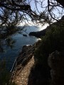
(1) At the end of the beach, follow the coastal road to the left and pass in front of the buildings. Continue along the path remaining close to the sea.

(2) Walk along a wall once you have passed the door through the rock protruding into the sea, and then go to the Cap Gros along the edge of the sea.

(3) Go left along the wall to get closer to the sea and continue on the path. Pass the Château de la Croé then climb up on the right via the Chemin des Douaniers. Follow the edge of the Château de la Croé grounds and at the end, turn left then right along the path.

(4) At the crossing, turn left then left again after a hundred meters to look at the Villa Eilenroc. Retrace your steps and continue straight along the Avenue Mrs Beaumont until the boulevard.

(5) Take the Boulevard John Fitzgerald Kennedy on the right, then turn immediately right on the Avenue Tour Gandolphe. Follow this avenue until the roundabout and go straight over onto the Avenue André Sella. Follow it to return to the Garoupe beach and your starting point (D/A).

Waypoints :
D/A : km 0 - alt. 5 m
1 : km 0.08 - alt. 5 m - Follow the coastal path along the buildings
2 : km 0.78 - alt. 6 m - Passage under the rock
3 : km 1.43 - alt. 8 m - Keep left on coastal path
4 : km 2.96 - alt. 33 m - Turn left on the surfaced road
5 : km 3.95 - alt. 35 m - Take the boulevard to the right
D/A : km 4.95 - alt. 5 m

Useful Information

Attention
Most of the route (between the starting point and the departure and the Château La Croé) is exposed to the sun, especially in the morning. You walk on rocks, stone, along the edge of the sea and a stone wall, without any shade, where the sun is amplified by the reflection. The route is not long but can be difficult if you don't handle the heat well.
Wear a hat or cap, take lots of water and particularly sunscreen. Don't take this path in rough weather, it is Dangerous.

Visorando and this author cannot be held responsible in the case of accidents or problems occuring on this walk.

During the walk or to do/see around

The city of Antibes as well as the port and its amazing boats
The tower
The Château de la Croé, an architectural masterpiece
The Villa Eilenroc
The colour of the sea!

Opinions and comments

Average

Global average : 4/5
Number of opinions : 2
Clarity of route description : 4/5
Clarity of route map : 4/5
Walk interest : 4/5


Walker
on Mon 29 Oct 2018 09:24:31 EDT

Global average : 4 / 5

Date of walk : 22/10/18
Clarity of route description : ★★★★☆ Good
Clarity of route map : ★★★★☆ Good
Walk interest : ★★★★☆ Good

The "smugglers" walk was an interesting walk but was still quite busy at the end of October. It was well signed and was paved for most of the way. We had walked out to the Cap from Antibes so only did half the route. We headed inland near the villa Eilenroc and caught a bus back to Antibes from a stop where the lane met the main road. Do take plenty of water as apart from the restaurant at the beach where you start there is nowhere else to get a drink.


Walker
on Wed 04 Jan 2017 14:07:53 EST

Global average : 4 / 5

Date of walk : 31/03/17
Clarity of route description : ★★★★☆ Good
Clarity of route map : ★★★★☆ Good
Walk interest : ★★★★☆ Good

This is a lovely little walk. The sea was calm and the January sun was shining. The scenery is breathtaking, with great views of the sea and, in the far distance, Nice and the alps. The trail is paved with flattened natural stones that blend in between the surrounding rocks. Stairs are made where needed, which is often the case. We did visit the villa Eilenroc as suggested. We found out that Eilenroc is actually an anagram of Cornelie, first name of the wife of Dutchman Loudon, that built the villa in 1860. The toilets next to the villa are a later addition, but did come in handy. The gardens (and rosarium) are worth a visit and we could also take a look inside and explore the ground floor of the villa. All in all a pleasant and easy walk. Among the many families, couples and sporty individuals that had chosen to follow the trail as their afternoon activity, we saw a mother with a pram negotiating the stairs with some difficulty. Although she was certainly out of her depth, this walk is indeed more of a Sunday afternoon stroll than anything else.

Other walks in the area

For more walks, use our search engine.

The GPS track and description are the property of the author.

Loading