


Sj3b

 Visorando Member
 Premium user
 Sign up:
Published route(s)
 Theth - Maja e Zorzit

 6.79 mi
 +4,163 ft
 -4,163 ft
 6h 45
6h 45
 Difficult
 Departure from Albania
Circular route from Theth to the Maja e Zorzit summit
This is the sister hike to the famous return route to Valbona, on the opposite side of the valley.
But whereas the route to Valbona can be somewhat lacking as it is mainly through forest with a single viewpoint at the summit, this circular loop of equivalent difficulty is much less frequented and, above all, offers numerous and varied views of the Theth Valley to the north, Shala to the south, and the Ukut massif and Bogë Valley to the west, as well as the Grunas waterfall to the east.
Allow at least 6 hours or so, including a few breaks.
The ascent does not present any particular technical challenges and allows everyone to set their own pace (note: the reverse route, however, involves a technical descent!).
The return descent route can easily be shortened or extended depending on your fitness level, as it runs close to the road, which remains quiet.
Lagoa do Fogo
 6.64 mi
+1,601 ft
-1,601 ft
4h 25
6.64 mi
+1,601 ft
-1,601 ft
4h 25
 Moderate
Departure from Vila Franca do Campo (Azores)
Moderate
Departure from Vila Franca do Campo (Azores)
Return to the shore of Lago do Fogo
Starting from the car park at the foot of the slope, the road remains a wide track until it turns into a path after a hotel complex.
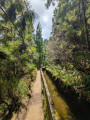
After a steeper section, the route becomes almost flat and runs alongside an irrigation channel under the trees, finally opening out onto a clearing where several channels converge from the hills above.
The viewpoint over the lake is then close by, and you can continue by following the track to the right.
Flores PR®03 - Poço do Bacalhau / Miradouro das Lagoas
 7.93 mi
+2,510 ft
-2,539 ft
5h 50
Moderate
Departure from Lajes das Flores (Azores)
7.93 mi
+2,510 ft
-2,539 ft
5h 50
Moderate
Departure from Lajes das Flores (Azores)
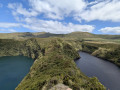
PR®03 trail (round trip) starting from the Bacalhau waterfall and circular route around the lakes
Allow between 4 and 5 hours without breaks
Numerous iconic viewpoints of the island (west coast, waterfalls, lakes) with a steep first section (gradient: 30%) before following a ridge to reach the lakes reserve.
Ponta - Miradouro da Quebrada dos Fanais (section of the PR®01)
 5.14 mi
+2,536 ft
-2,533 ft
4h 35
Moderate
Departure from Lajes das Flores (Azores)
5.14 mi
+2,536 ft
-2,533 ft
4h 35
Moderate
Departure from Lajes das Flores (Azores)
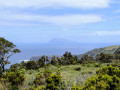
Return trip from Ponta to the Miradouro da Quebrada dos Fanais (viewpoint overlooking the lighthouse and Corvo)
There are also some very beautiful views of Ponta, Faja Grande and the island’s west coast.
Start from the car park behind the church in Ponta, on a red/yellow-marked trail like all hiking trails in the Azores.
The path initially runs along the coast before branching off to the right via a small, unobtrusive staircase that marks the start of the ascent.
The climb is not difficult but is made all the more enjoyable by the dense vegetation and the views of the ocean. There are a few sections with handrails or wooden steps.
Once at the top, the path follows the stone walls to the viewpoint overlooking the lighthouse and Corvo.
The trail continues on to Ponta Delgada, a distance of 5–6 km, mostly downhill.
Baia da Alagoa
 0.46 mi
+200 ft
-236 ft
0h 25
0.46 mi
+200 ft
-236 ft
0h 25
 Easy
Departure from Santa Cruz das Flores (Azores)
Easy
Departure from Santa Cruz das Flores (Azores)
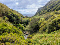
A short, easy walk to reach Alagoa Bay/Beach.
No particular difficulty; the path is very well signposted (red and white).
From the main road, turn right at the bend onto a recently tarmac-surfaced road. At the end of the road is the car park where you can start the walk.
Halfway along, there is a superb spot to spend the day or have a meal, with sheltered tables, toilets, showers, a BBQ and bins available.
The path continues to the left until you reach the beach.
Depending on the weather and your swimming ability, you can swim out to the hollow rock opposite the beach.
Circular route through the vineyards between Santana and Lajido, returning via Santa Luzia
 8.95 mi
+981 ft
-961 ft
5h 00
Moderate
Departure from São Roque do Pico (Azores)
8.95 mi
+981 ft
-961 ft
5h 00
Moderate
Departure from São Roque do Pico (Azores)
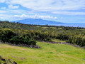
Hike through the vineyards of the north coast between Santana and Lajido (UNESCO-listed)
The coastal section allows you to walk across the lava flows and their iconic landscape, as well as through the beautiful hamlets of Arcos and Lajido. The route also offers stunning views of the two neighbouring islands: Calneta to the north-east and Horta to the east, as well as a passage through a volcanic arch.
The inland section takes you through the vineyards and up a little to enjoy the many views of the neighbouring islands and the Montanha do Pico.
A circular route that largely follows the route of the PR®10 and PR®01 – straightforward paths – but avoids sections of the main road (ER) in favour of much less busy tracks.
Red/Yellow markings.
The route starts here at the junction between the ‘lava’ section and the ‘hills’ section. It is also possible to start from either of the two villages and follow the same route.