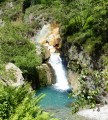
The Artigue waterfalls

A gentle walk to the Artigue waterfalls.

Technical sheet

271
Creation:
Last update:
Last review:
  • Walking
    Activity: Walking
  • ↔
    Distance: 2.93 km
  • ◔
    Average duration: 1h 10 
  • ▲
    Difficulty: Easy

  • ⚐
    Return to departure point: Yes
  • ↗
    Vertical gain: + 130 m
  • ↘
    Vertical drop: - 133 m

  • ▲
    Highest point: 1,276 m
  • ▼
    Lowest point: 1,173 m

Photos

Description of the walk

Park at the power station car park at the very end of the D66.

Take the path to the west. At the fork (1), ignore the path on the right to Orris de Mespelat and continue straight on, following the Artigue river for about fifteen minutes. At 1203m, a footbridge takes you across the river onto the right bank. (2). After ten minutes you will reach a fork on the right leading to the Artigue waterfalls. (3). Walk through the undergrowth, with blueberry bushes on either side of the path, until you reach the steep banks of the Artigue. The most dramatic spot is where the Estats and Artigue rivers meet.

Return to the car park along the same route.

Waypoints

  1. S/E : km 0 - alt. 1,177 m - Power station car park
  2. 1 : km 0.42 - alt. 1,185 m - Bifurcation
  3. 2 : km 0.86 - alt. 1,226 m - Bifurcation
  4. 3 : km 1.46 - alt. 1,276 m - Artigue waterfalls
  5. S/E : km 2.93 - alt. 1,177 m - Power station car park

Practical information

Travelling along the D8, after Auzat, bypass the village of Marc, ignoring the road to the Etang de Soulcem on the left, and turn right onto the D66 to L'Artigue. As you drive past the abandoned Chalet de Montcalm, the road crosses the Artigue onto the left bank, and then takes you straight on to the power station car park.

Reviews and comments

4.6 / 5
Based on 81 reviews

Reliability of the description
4.5 / 5
Clarity of route map
4.6 / 5
Route interest
4.6 / 5
Amneloris
Amneloris

Hello,

I saw on another site that there was potentially a loop possible, joining the waterfalls a little upstream, then branching off to the north.
But I have the impression that it's not really signposted...

Do you have any information on this?

Automatically translated

User 26010296

Overall rating : 5 / 5

Date of walk : Jun 01, 2025
Reliability of the description : ★★★★★ Very good
Clarity of route map : ★★★★★ Very good
Route interest : ★★★★★ Very good
Busy trail : Yes

Magnificent! Completely accessible for children! Get ready to be amazed!

Automatically translated

Éléa
Éléa

Overall rating : 5 / 5

Date of walk : Nov 23, 2024
Reliability of the description : ★★★★★ Very good
Clarity of route map : ★★★★★ Very good
Route interest : ★★★★★ Very good
Busy trail : No

Lovely walk with little difference in height or distance. We did it as a family in autumn in fine, dry, cold weather. We didn't meet many hikers and were alone picnicking above the waterfall. Our little one, who will soon be 4, walked the whole way. It's lovely to walk alongside the stream, following the path through the trees and mossy rocks. The waterfall, pools and water colours are magnificent. Do it again in fine weather!

Automatically translated

chtimi
chtimi

Overall rating : 5 / 5

Date of walk : Sep 16, 2024
Reliability of the description : ★★★★★ Very good
Clarity of route map : ★★★★★ Very good
Route interest : ★★★★★ Very good
Busy trail : No

Precise and pretty. I recommend walking shoes.

Automatically translated

nadmich
nadmich

Overall rating : 5 / 5

Date of walk : Aug 28, 2024
Reliability of the description : ★★★★★ Very good
Clarity of route map : ★★★★★ Very good
Route interest : ★★★★★ Very good
Busy trail : Yes

A short, easy walk in the shade with children... but be warned, as we reached the waterfall, the descent to the torrent was very slippery and there was very little space to rest and picnic as it was a swimming area. We turned back to find a nice spot on the banks of the torrent to play and soak our feet in the peace and quiet.

Automatically translated

BUBU33
BUBU33

Overall rating : 5 / 5

Date of walk : Aug 25, 2024
Reliability of the description : ★★★★★ Very good
Clarity of route map : ★★★★★ Very good
Route interest : ★★★★★ Very good
Busy trail : Yes

Hello,

We did this walk at the beginning of August with a small variation, leaving on a forest track from the small bridge before the last car park, so that we didn't meet anyone on the way to the waterfall, which meant a greater difference in height but was nicer...
Then the stop at the waterfall is overcrowded at this time of year, but you can find a place! Then if you're keen on jumping into the water, the spot is perfect!
But as this walk is a local must, it's still very busy!

Automatically translated

Jean Claude 31
Jean Claude 31

Overall rating : 4.3 / 5

Date of walk : Aug 09, 2024
Reliability of the description : ★★★★☆ Good
Clarity of route map : ★★★★★ Very good
Route interest : ★★★★☆ Good
Busy trail : Yes

Nice little walk. Shady, pleasant route in the heat.

Automatically translated

Elpipine
Elpipine
• Last modified:

Overall rating : 4.7 / 5

Date of walk : Jul 28, 2024
Reliability of the description : ★★★★★ Very good
Clarity of route map : ★★★★★ Very good
Route interest : ★★★★☆ Good
Busy trail : Yes

It's an easy walk, and the waterfall means you can jump into the water if you're feeling hot!
Car park full on arrival!

Automatically translated

Christine_aix
Christine_aix

Overall rating : 5 / 5

Date of walk : Jun 23, 2024
Reliability of the description : N/A
Clarity of route map : ★★★★★ Very good
Route interest : ★★★★★ Very good
Busy trail : No

A very pretty little walk with no difficulties.
The route is described as far as the first waterfall, and as another hiker said, it's worth continuing a little to see another waterfall, which is quite impressive this year because of the heavy rainfall. However, the path is a little more difficult.

Automatically translated

mucast
mucast

Overall rating : 4.7 / 5

Date of walk : Apr 21, 2024
Reliability of the description : ★★★★★ Very good
Clarity of route map : ★★★★★ Very good
Route interest : ★★★★☆ Good
Busy trail : No

we didn't realise straight away that it was the end, so we went too far!
but otherwise great

Automatically translated

Ren007
Ren007

Overall rating : 4.7 / 5

Date of walk : Aug 17, 2023
Reliability of the description : ★★★★★ Very good
Clarity of route map : ★★★★★ Very good
Route interest : ★★★★☆ Good
Busy trail : Yes

Easy walk, fairly well-travelled path

Automatically translated

Mamiestellou79
Mamiestellou79

Overall rating : 4.3 / 5

Date of walk : Sep 03, 2023
Reliability of the description : ★★★★☆ Good
Clarity of route map : ★★★★☆ Good
Route interest : ★★★★★ Very good
Busy trail : Yes

Great route along the waterfalls. The starting point of the application is not very well signposted. You have to follow the main path. After that, you don't need your phone anyway, the path is all mapped out. Magnificent scenery at the finish. It's worth the effort and quite easy.

Automatically translated

Yves Pomié
Yves Pomié

Overall rating : 5 / 5

Date of walk : Aug 08, 2023
Reliability of the description : ★★★★★ Very good
Clarity of route map : ★★★★★ Very good
Route interest : ★★★★★ Very good
Busy trail : Yes

A very pleasant walk in warm weather. You can picnic by the water and dip your feet in the cool water. Lovely shady setting.

Automatically translated

Christophe1030
Christophe1030

Overall rating : 4.7 / 5

Date of walk : Aug 08, 2023
Reliability of the description : ★★★★★ Very good
Clarity of route map : ★★★★★ Very good
Route interest : ★★★★☆ Good
Busy trail : Yes

A lovely, easy hike (done with my 12-year-old daughter, who is not at all sporty), with the only problem being the crowds at the car park and at the first waterfall...so in my opinion, if your aim is to relax with your feet in the water, go on a very hot day in the morning!

Automatically translated

sousou13xque
sousou13xque
• Last modified:

Overall rating : 5 / 5

Date of walk : Jul 31, 2023
Reliability of the description : ★★★★★ Very good
Clarity of route map : ★★★★★ Very good
Route interest : ★★★★★ Very good
Busy trail : Yes

Super hike,
Rather quick and easy to get to, I'd recommend it for a last-minute hike.
Be careful though, rather rocky!
Shady spot, 30°C walk and yet no sensation of heat.
Some nice climbs, followed by flat sections...

Automatically translated

For more walks, use our search engine .

The GPS track and description are the property of the author. Do not copy them without permission.