


De Echte Stadswandeling
Details
Creation:
Last update:
–
–
-
 Activity: Walking
 -
 Distance: 2.91 mi
 -
 Average duration: 1h 20
 -
 Difficulty: Not specified
 -
-
 Back to start: No
 -
 Ascent: + 33 ft
 -
 Descent: - 135 ft
 -
-
 Highest point: 436 ft
 -
 Lowest point: 308 ft
-
 Start: N 54.674898° / E 25.289347°
 -
 End: N 54.6882° / E 25.27032°
 -


 Hour-by-hour weather


Waypoints
- S : mi 0 - alt. 436 ft
- 1 : mi 0 - alt. 436 ft - Head north on Aušros Vartų g. toward Pasažo skg.
- 2 : mi 0.14 - alt. 404 ft - Continue onto Didžioji g.
- 3 : mi 0.25 - alt. 381 ft - Turn left
- 4 : mi 0.26 - alt. 381 ft - Head southeast toward Didžioji g.
- 5 : mi 0.27 - alt. 381 ft - Turn right onto Didžioji g.
- 6 : mi 0.39 - alt. 404 ft - Turn left onto SubaÄiaus g.
- 7 : mi 0.54 - alt. 423 ft - Turn left onto Bokšto g.
- 8 : mi 0.6 - alt. 404 ft - Head north on Bokšto g. toward Šv. Kazimiero g.
- 9 : mi 0.67 - alt. 371 ft - Turn right onto O. Å imaitÄ—s g.
- 10 : mi 0.73 - alt. 348 ft - Turn left toward Maironio g.
- 11 : mi 0.83 - alt. 331 ft - Turn right toward Maironio g.
- 12 : mi 0.84 - alt. 328 ft - Turn left onto Maironio g.
- 13 : mi 0.89 - alt. 338 ft - Turn right onto Užupio g.
- 14 : mi 1.02 - alt. 335 ft - Turn right onto Paupio g.
- 15 : mi 1.02 - alt. 335 ft - Head northwest on Paupio g. toward Užupio g.
- 16 : mi 1.03 - alt. 335 ft - Continue onto Malūnų g.
- 17 : mi 1.15 - alt. 312 ft - Turn right onto Maironio g.
- 18 : mi 1.25 - alt. 328 ft - Head north on Maironio g. toward B. RadvilaitÄ—s g.
- 19 : mi 1.38 - alt. 312 ft - Maironio g. turns slightly left and becomes B. RadvilaitÄ—s g.
- 20 : mi 1.42 - alt. 318 ft - Turn right
- 21 : mi 1.44 - alt. 322 ft - Turn left
- 22 : mi 1.49 - alt. 328 ft - Turn right
- 23 : mi 1.5 - alt. 331 ft - Turn left
- 24 : mi 1.52 - alt. 338 ft - Turn right
- 25 : mi 1.52 - alt. 338 ft - Slight left
- 26 : mi 1.68 - alt. 371 ft - Slight left
- 27 : mi 1.75 - alt. 394 ft - Head east
- 28 : mi 2.09 - alt. 318 ft - Turn right
- 29 : mi 2.2 - alt. 308 ft - Head west toward Å ventaragio g.
- 30 : mi 2.22 - alt. 308 ft - Continue onto Gedimino pr.
- 31 : mi 2.87 - alt. 335 ft - Turn left
- E : mi 2.91 - alt. 341 ft
Other walks in the area
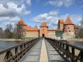
Trakai Island Castle, on the shores of Lake Galvė
 Visorando Member
 2.11 mi
+23 ft
-20 ft
1h 00
2.11 mi
+23 ft
-20 ft
1h 00
 Easy
Easy
On the shores of Lake Galvė, west of Vilnius, this circular route takes you around one of Lithuania’s most iconic sites: Trakai Island Castle, a red-brick Gothic fortress set on the water and connected to the mainland by long wooden footbridges. The route first heads up Karaimų Street, the historic heart of the Karaite community with its traditional wooden houses, before reaching the castle island and then a viewpoint offering a full view of the castle rising above the lake, before returning along the lakeshore. An easy stroll, combining heritage and water, ideal for a half-day in Trakai.
For more walks, use our search engine .
The GPS track and description are the property of this route's author. Please do not copy them without permission.

