Circular Heritage Walk in Vittel

Throughout this walk, you’ll discover two spa towns (Vittel and Contrexéville) and all they have to offer. You’ll also pass through Bulgnéville, Mandres-sur-Vair and Norroy-sur-Vair, before returning to your starting point.

Details

43484469
Creation:
Last update:
Last review:
  • Touring/Gravel
    Activity: Touring/Gravel
  • ↔
    Distance: 18.99 mi
  • ◔
    Duration according to the author: 2.5 hrs 
  • ▲
    Difficulty: Difficult

  • ⚐
    Back to start: Yes
  • ↗
    Ascent: + 837 ft
  • ↘
    Descent: - 846 ft

  • ▲
    Highest point: 1,417 ft
  • ▼
    Lowest point: 1,063 ft
  • ⚐ Country: France
  • ⚐ City: Vittel (88800)
  • ⚑
    Start/End: N 48.204702° / E 5.941732°
  • Accessible from the train station Gare de Contrexéville.
  • ❏
    IGN map(s): Ref. 3318SB

  • ◶
    Type of surface:
  •  
     
     50% Road  50% Byway
  • Hour-by-hour weather

Photos

Description of the route

The route starts at the Vittel spa park.

(S/E) Opposite the entrance to the thermal park, turn right onto Avenue Bouloumié, heading towards the town centre. You’ll come to a roundabout.

(1) Take the first exit, pass the town hall and follow Avenue Raymond Poincaré all the way up, staying on the cycle path. Continue straight on towards Rue du Lieutenant Gaufre until you reach the roundabout by the gendarmerie. Turn right and follow the cycle path again to the end, at the edge of the forest.

(2) Turn left, enter the forest and immediately turn right. Cross the bridge over a departmental road, then head back into the woods. You’ll come to a junction.

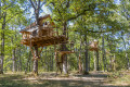
(3) At the fork, turn left. You’ll reach the Vittel Forest Park; keep to the right, then turn left twice onto a path. Pass the unusual huts and the wildlife park, then continue to the far end.

(4) At the cross-path, keep to the right and carry on straight ahead until you reach the hills above Contrexéville.

(5) Turn right in front of the sports ground, then arrive in front of the secondary school. Turn left and walk down Avenue du Bois d’Hazau, going straight across the roundabout. You’ll come to a set of traffic lights.

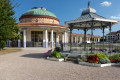
(6) Turn left, then right, and pass the Galerie Thermale and the Tourist Office. At the roundabout, take the first exit, cross the railway line and you’ll soon reach a junction.

(7) Turn sharply left towards the campsite. Just past the campsite, on the outskirts of town, turn right onto a forest track and head towards a crossroads of tracks.

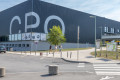
(8) Turn right onto a long, straight track and you’ll reach the recycling centre. Keep to the right and join the road (D164).

(9) Turn left, go under the road bridge (caution! The road is winding) and, this time, cross the bridge over the dual carriageway. Enter Bulgnéville and continue straight on until you reach Place Henri Guillemaut.

(10) Carry on to the right onto the D17 towards Mandres-sur-Vair, pass the church, then, in front of the town hall and at the Stop sign, turn right onto Rue du Gravé. Drive the full length of the car park and carry on straight ahead. The tarmac road passes under the dual carriageway and becomes a track.

(11) Carry on straight ahead, passing the Fontaine du Naingrecourt, and keep going straight on. You will then enter a wooded area; at the end of the track, turn right, then left at the next junction. You will reach a cross-country track.

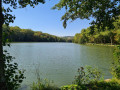
(12) Turn right and quickly leave the track to take a forest path on the right. Walk a few metres and turn left. At the end of the path, rejoin a track, turn right, then immediately left. Carry on straight ahead until you reach the Lacs de la Folie site in Contrexéville.

(13) Follow the embankment separating the two lakes. Once you’ve left the embankment, walk along an open area, then enter the forest. Take thefirst path on the left, which turns into a forest track. At the fork, take the path on the right and continue straight on until you reach the next crossroads.

(14) Take the path on the right and join a track running alongside the forest. At the end of this, you’ll reach the road (D13). Turn left and continue along the main road until you reach the church at Mandres-sur-Vair.

(15) Turn right, towards Norroy. You’ll reach a junction just after the bridge over the Vair.

(16) Carry on to the right. You’ll reach Norroy and thefirst junction.

(17) Turn left, pass the town hall and follow theD18A to its end. At the junction, turn right onto the D18, towards Vittel. Pass the ‘L’Orée du Bois’ hotel and restaurant, then turn immediately left towards the racecourse. You’ll come to a sports ground.

(18) Turn left, then, at the end of the path, turn left again. Walk a few metres and turn right, cross the bridge over the Petit Vair, then turn right again. Continue along the concrete path until you reach a junction.

(19) Take the path through the wooded area to reach the Vittel Thermal Park. Walk up the wide avenue to the Palais des Congrès, walk along its left-hand side and return to the starting point (S/E).

Waypoints

  1. S/E : mi 0 - alt. 1,102 ft - Thermal Park – Vittel
  2. 1 : mi 0.16 - alt. 1,115 ft - Roundabout, first right
  3. 2 : mi 1.08 - alt. 1,243 ft - Edge of the forest
  4. 3 : mi 1.32 - alt. 1,234 ft - Carrefour
  5. 4 : mi 2.2 - alt. 1,286 ft - End of the road
  6. 5 : mi 3.39 - alt. 1,230 ft - Contrexéville
  7. 6 : mi 3.89 - alt. 1,102 ft - Traffic lights - Suriauville (ruisseau) - Affluent du Vair
  8. 7 : mi 4.26 - alt. 1,145 ft - Railway line, hairpin bend - Gare de Contrexéville
  9. 8 : mi 5.03 - alt. 1,211 ft - Carrefour
  10. 9 : mi 5.92 - alt. 1,250 ft - Road (D164)
  11. 10 : mi 8.67 - alt. 1,138 ft - Bulgnéville - Lac des Recollets (Bulgnéville)
  12. 11 : mi 9.35 - alt. 1,181 ft - Express route
  13. 12 : mi 10.44 - alt. 1,358 ft - End of the road
  14. 13 : mi 11.4 - alt. 1,115 ft - Lacs de la Folie (Contrexeville)
  15. 14 : mi 12.16 - alt. 1,125 ft - Carrefour - Arceau (ruisseau) - Affluent du Vair
  16. 15 : mi 14.47 - alt. 1,096 ft - Mandres-sur-Vair
  17. 16 : mi 14.79 - alt. 1,066 ft - Vair (rivière)
  18. 17 : mi 16.02 - alt. 1,168 ft - Norroy
  19. 18 : mi 17.45 - alt. 1,083 ft - Sports ground
  20. 19 : mi 18.55 - alt. 1,093 ft - Hippodrome junction
  21. S/E : mi 18.99 - alt. 1,102 ft - Thermal Park – Vittel

Worth a visit

Places to visit along the way:
- Vittel Thermal Park
- Vittel Forest Park
- Contrexéville Spa Gallery
- Naingrecourt Fountain
- La Folie Lakes
- Mandres-sur-Vair
- Norroy
- Racecourse

Find a wide range of activities in Contrexéville right here: https://www.contrextourisme.com/

Reviews and comments

4.8 / 5
Based on 2 reviews

Reliability of the description
5 / 5
Ease of following the route
5 / 5
Route interest
4.5 / 5
Flibustier42
Flibustier42
CharlotteBuqlier
CharlotteBuqlier

Thank you for these details, which will certainly be useful to our future visitors We’re delighted that you enjoyed your visit. We look forward to seeing you again in Contrexéville!

Machine-translated

Flibustier42
Flibustier42
• Edited:

Overall rating : 5 / 5

Date of your route : Aug 03, 2024
Reliability of the description : ★★★★★ Very good
Ease of following the route : ★★★★★ Very good
Route interest : ★★★★★ Very good
Very busy route : No

I left the trail just before (9), at the recycling centre, to head left towards Lac des Récoltets (yellow/white signposts), then, on reaching a junction, I headed towards Lac de Saulxures, and from there, back towards Lac des Récoltets, where I rejoined the trail at point (10).
I really enjoyed this slightly more mountain bike/trail-oriented route: there’s a lovely, gentle descent down to Lac de Saulxures, which is a real pleasure.
Also, at Lac de Contrex (13), I took the GR517 towards Vittel, where, again, this alternative route is much more mountain bike-oriented, and you can rejoin the route at the point (18).
The distances are almost identical. And much more fun than the road 🤘
The original route might be better suited to gravel biking than mountain biking.

Machine-translated

Contrexéville Tourisme

Thank you for sharing your experience; we’re delighted that you were able to enjoy this route around Contrexéville and discover the three lakes at Contrexéville, Bulgnéville and Saulxures. We look forward to seeing you again in our beautiful region!

Machine-translated

Vélo top
Vélo top

Overall rating : 4.7 / 5

Date of your route : Jun 07, 2024
Reliability of the description : ★★★★★ Very good
Ease of following the route : ★★★★★ Very good
Route interest : ★★★★☆ Good
Very busy route : Yes

Hello,
We went for a ride during the week and visited several towns and three lakes, which we added to the circular route, and we had no trouble finding our way back to the starting point. It was a very pleasant cycle ride; we had lunch at the Étang des Ricollets and stopped off at the Bulgnéville cheese shop to buy a piece of cheese. Then we returned to the starting point.

Machine-translated

For more walks, use our search engine .

The GPS track and description are the property of this route's author. Please do not copy them without permission.