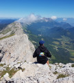
Pico Ruivo from Achada de Teixeira

Climb to the highest point of the island of Madeira, taking the easier route. Beautiful mountain scenery and a superb 360° panorama at the top.

Technical sheet

118168
Creation:
Last update:
Last review:
  • Walking
    Activity: Walking
  • ↔
    Distance: 5.38 km
  • ◔
    Average duration: 3h 00 
  • ▲
    Difficulty: Moderate

  • ⚐
    Return to departure point: Yes
  • ↗
    Vertical gain: + 522 m
  • ↘
    Vertical drop: - 515 m

  • ▲
    Highest point: 1,833 m
  • ▼
    Lowest point: 1,580 m

Photos

Description of the walk

Start & Parking: Park at Achada do Teixeira in the car park located at the end of the EN-101-5 road from Santana.

Yellow and Red waymarkers (Trail no. 1.2).

(S) From the car park (hike information on a sign), take the path that starts in a west-southwest direction. Gently climb and pass over the summit at around 1,700 m and then down again.

(1) At the junction with the trail No. 1.1, from the right, continue to the west. Head onto a ledge and climb up to reach the Poussada do Ruivo (shelter).

(2) Continue west for roughly another 250 m.

(3) Turn left (south) to climb in loops all the way to the summit.

(4) Return by the outbound route. (E)

Waypoints

  1. S/E : km 0 - alt. 1,580 m - Achada do Teixeira
  2. 1 : km 1.61 - alt. 1,724 m - Junction of trails PR1.2 and PR1.1
  3. 2 : km 2.24 - alt. 1,755 m - Poussada do Ruivo
  4. 3 : km 2.45 - alt. 1,803 m - Junction at the foot of Pico Ruivo
  5. 4 : km 2.69 - alt. 1,801 m - Pico Ruivo - Summit
  6. S/E : km 5.38 - alt. 1,580 m - Achada do Teixeira

Practical information

Start & Parking: Park at Achada do Teixeira in the car park located at the end of the EN-101-5 road from Santana.

Waymarkers: Yellow and Red waymarkers (Trail no. 1.2).

Terrain & Gears: The trail is laid out with paving stones and, in places, cable rails on the sides. Even so, bring good hiking boots.
Despite the latitude, the climate is changeable: I recommend bringing warm clothing and starting early to avoid the fog that can fall quickly.

Facilities: Shelter at Poussada do Ruivo.

In the nearby area

From the top, there is a 360° view of the island of Madeira and the ocean.

On the way, the area where the high-altitude grasslands dominate, gives a pleasant mountain atmosphere.

Reviews and comments

4.9 / 5
Based on 23 reviews

Reliability of the description
4.9 / 5
Clarity of route map
4.9 / 5
Route interest
4.8 / 5
PierrickBZH
PierrickBZH

Overall rating : 5 / 5

Date of walk : Jun 05, 2025
Reliability of the description : ★★★★★ Very good
Clarity of route map : ★★★★★ Very good
Route interest : ★★★★★ Very good
Busy trail : Yes

A very fine easy to medium level walk with some exceptional views.
Correct description of the route
We did it in 2h30

Automatically translated

Chaden
Chaden

Overall rating : 5 / 5

Date of walk : Apr 23, 2025
Reliability of the description : ★★★★★ Very good
Clarity of route map : ★★★★★ Very good
Route interest : ★★★★★ Very good
Busy trail : Yes

Magnificent hike to the top of Madeira. We drove all the way up to Achada de Teixeira in the fog. The sun came out a little at the car park. Then the weather cleared all the way up. In 1 hour 30 minutes, we were at the top and enjoying the magnificent views of the surrounding mountains, particularly Pico Areiro.
Thanks to the author for this hike!

Automatically translated

Cutchy
Cutchy

Overall rating : 5 / 5

Date of walk : Jan 28, 2025
Reliability of the description : ★★★★★ Very good
Clarity of route map : ★★★★★ Very good
Route interest : ★★★★★ Very good
Busy trail : Yes

A great hike that is a good alternative to the Pico do Arieiro -> Pico Ruivo traverse, which is currently closed.

The final climb is no longer closed as indicated in the previous comment, so you can reach the summit without climbing a fence.

Just after we left the summit, the clouds began to block the view, so it's best to do it early (midday at the summit is fine). Otherwise, the route is fairly straightforward, but very exposed to Madeira's winds.

The hike costs €3 per person, which you can pay in cash or via a card app, but it's well worth it.

Automatically translated

Ang76
Ang76

Overall rating : 5 / 5

Date of walk : Oct 20, 2024
Reliability of the description : ★★★★★ Very good
Clarity of route map : ★★★★★ Very good
Route interest : ★★★★★ Very good
Busy trail : Yes

A must-do if you're heading to Madeira! Easy and magnificent walk.
The final climb to the panorama is closed after the hostel following the summer fires, but despite this people climb the fence to get up there anyway. It's a shame this isn't indicated at the start of the route.
The views along the way are extraordinary. We did this walk in the morning on an overcast day, arriving at the car park above the clouds, which faded as the morning went on. The weather changes very quickly.

Automatically translated

mathieu9a
mathieu9a

Overall rating : 4.7 / 5

Date of walk : Oct 15, 2024
Reliability of the description : ★★★★★ Very good
Clarity of route map : ★★★★☆ Good
Route interest : ★★★★★ Very good
Busy trail : Yes

To watch the sunrise, leave the car park at least 2 hours before sunrise.
Don't forget to take :
- A torch
- Warm clothing
- A windbreaker
And enough to have a hot breakfast on arrival while contemplating the spectacle.
The climb is easy despite the altitude of 1860m.
The path is very practicable
Make sure you set off early to avoid the crowds and find a place to park.
Enjoy the show and the hike

Automatically translated

Belisaire
Belisaire

Overall rating : 5 / 5

Date of walk : Sep 06, 2024
Reliability of the description : ★★★★★ Very good
Clarity of route map : ★★★★★ Very good
Route interest : ★★★★★ Very good
Busy trail : Yes

It's easy to get to the car park (Waze or Google map) then follow the signs (stairs to the right of the coffee shop) - Take your time as it's a very busy walk! Hike done in the rain (can't win every time) but it's worth the trip!

Automatically translated

CoachDosh42
CoachDosh42

Overall rating : 5 / 5

Date of walk : Jun 02, 2024
Reliability of the description : ★★★★★ Very good
Clarity of route map : ★★★★★ Very good
Route interest : ★★★★★ Very good
Busy trail : Yes

Breathtaking scenery!
An easy hike, with only a slight gradient.
A word of advice: come early to enjoy the view without being in the clouds, but above all to avoid the throngs of tourists!

Automatically translated

LMDB
LMDB

Overall rating : 4.7 / 5

Date of walk : Jun 16, 2024
Reliability of the description : ★★★★★ Very good
Clarity of route map : ★★★★★ Very good
Route interest : ★★★★☆ Good
Busy trail : Yes

A great route to do in fine weather to enjoy the scenery.
Easy route

Automatically translated

faustinebrun
faustinebrun

Overall rating : 4.7 / 5

Date of walk : May 11, 2024
Reliability of the description : ★★★★★ Very good
Clarity of route map : ★★★★★ Very good
Route interest : ★★★★☆ Good
Busy trail : No

It's very easy to follow the path, everything is signposted. Beautiful viewpoint at the top of Pico Ruivo.
Come early to avoid the crowds

Automatically translated

chralto63
chralto63

Overall rating : 5 / 5

Date of walk : May 05, 2024
Reliability of the description : N/A
Clarity of route map : N/A
Route interest : ★★★★★ Very good
Busy trail : Yes

Well laid out and signposted route.
No need for a map.

Automatically translated

momone
momone

The fog was too thick at the summit, so we didn't dare set off in a blur, but the landscape, which cleared up from time to time only to become obscured again, was sublime.

Automatically translated

randidier
randidier

Overall rating : 5 / 5

Date of walk : Apr 01, 2023
Reliability of the description : ★★★★★ Very good
Clarity of route map : ★★★★★ Very good
Route interest : ★★★★★ Very good
Busy trail : Yes

You'll need to arrive early (before 9am), then you'll have to wait for someone to leave before you can park...
Superb walk above the clouds. Impossible to get lost, just follow the crowd...
Very windy at the summit, a windbreaker was appreciated.
Lots of steps: I counted 501 from the "summit at 500m" sign.

Automatically translated

stravers
stravers

Overall rating : 4.7 / 5

Date of walk : Sep 12, 2022
Reliability of the description : ★★★★☆ Good
Clarity of route map : ★★★★★ Very good
Route interest : ★★★★★ Very good
Busy trail : Yes

Easier than expected and signposted. 50 minutes to get to the top of Pico Ruivo with photo opportunities. Clear view from the summit.
So we took the path to pico Ariero.
As described by another hiker below, it's a very busy but difficult walk.
We had to turn back halfway up because the weather was becoming overcast with a little drizzle. Do the whole thing again sooner!

Automatically translated

osiris130
osiris130 ★

Overall rating : 5 / 5

Date of walk : Jul 28, 2022
Reliability of the description : ★★★★★ Very good
Clarity of route map : ★★★★★ Very good
Route interest : ★★★★★ Very good
Busy trail : Yes

A beautiful hike above the clouds, which created a very special atmosphere.

Access to the refuge is very easy. From there, you're on a mountain trail where, at the very least, good trainers (trail type) are recommended.

Lots of people... It's best to park early to avoid the clouds!

Automatically translated

masybou
masybou

Overall rating : 5 / 5

Date of walk : Jun 29, 2022
Reliability of the description : ★★★★★ Very good
Clarity of route map : ★★★★★ Very good
Route interest : ★★★★★ Very good
Busy trail : Yes

A very nice walk, but it's a shame we had clouds at the finish. We didn't get to see the magnificent panorama "promised". That said, the trail is superb.
Just as you described

Automatically translated

For more walks, use our search engine .

The GPS track and description are the property of the author. Do not copy them without permission.