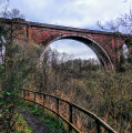
Ballochmyle Viaduct from Catrine

Starting in Catrine, follow the course of the River Ayr through woodland to the impressive Ballochmyle Viaduct. It is the highest masonry railway viaduct in Britain and even featured in a scene in the movie Mission: Impossible!

Technical sheet

24135246
A East Ayrshire walk posted on 18/07/22 by Gillian's Walks. Last update : 20/07/22
  • Walking
    Activity: Walking
  • ↔
    Distance: 5.56 km
  • ◔
    Calculated time: 1h 35 
  • ▲
    Difficulty: Easy

  • ⚐
    Return to departure point: Yes
  • ↗
    Vertical gain: + 9 m
  • ↘
    Vertical drop: - 9 m

  • ▲
    Highest point: 105 m
  • ▼
    Lowest point: 91 m
Ballochmyle Viaduct

Description

(S/E) The walk starts at Mill Square, Catrine. Exit Mill Square onto Bridge Street (opposite side from the main road).

At the end of Bridge Street continue ahead (South) to cross the bridge over the River Ayr.

(1) Almost immediately turn right (North West) to cross a burn.

Turn right (North) and walk along Holm Farm Road. The River Ayr should be on your right-hand side.

(2) After the last house at a bend in the road, continue straight ahead (North West) onto a narrow earth path. The River Ayr should still be on your right-hand side.

(3) Continue to follow this path along the river, passing beneath the A76 viaduct after 1.2km.

Go down some steps to meet up with a minor road. Turn right (West) and cross a stone bridge over the river.

(4) Continue along the road for approx 500m until you reach a footpath on your left with River Ayr Way signage on the gate. At the other side of the gate is a large grassy area.

The path takes you West across the grassy area and into the woods.

(5) Stick to the main footpath through the woods, crossing a footbridge and arriving at the Ballochmyle Viaduct after approx 300m.

Return to Mill Square, Catrine via the same route (S/E)

Waypoints

  1. S/E : km 0 - alt. 96 m - Mill Square, Catrine
  2. 1 : km 0.16 - alt. 94 m - Right turn to cross burn
  3. 2 : km 0.56 - alt. 91 m - Narrow earth path ahead
  4. 3 : km 1.77 - alt. 103 m - A76 viaduct
  5. 4 : km 2.42 - alt. 102 m - Footpath on left with River Ayr Way sign on gate
  6. 5 : km 2.78 - alt. 102 m - Ballochmyle Viaduct
  7. S/E : km 5.56 - alt. 96 m - Mill Square, Catrine

Useful Information

For more information and a route review visit Gillian's Walks

Transport

  • There is a public car park on corner of Wood Street, Catrine (KA5 6RJ)
  • There is also a local bus service with stops at Mill Square, at the start of the route

Terrain
Mostly earth footpaths and quiet roads but can be muddy at times. There are some steps on this route.

Always stay careful and alert while following a route. Visorando and the author of this walk cannot be held responsible in the event of an accident during this route.

During the walk or to do/see around

  • Catrine - former cotton mill town
  • Ballochmyle Railway Viaduct - highest masonry railway viaduct in Britain. Featured in a scene in the movie Mission: Impossible! Now a category ‘A’ listed building.
  • River Ayr Way - a long distance route following the course of the River Ayr from its source to the sea. Since the route passes through Catrine, you can extend this walk in either direction towards Failford or Sorn.
  • Optional de-tour to one of the most extensive areas of ring and cup marks ever found in the UK: at (4) veer right across the grassy area, along a faint footpath heading towards some trees and a small stream. Cross the wire fence and then the stream and straight ahead through the trees you will come to a large block of red sandstone which is home to the ring and cup marks. The ground here is extremely uneven and muddy so do take care.
  • Catrine Voes and Weir Local Nature Reserve

Other walks in the area

For more walks, use our search engine.

The GPS track and description are the property of the author.

Loading…